
Join the Cause:
Let's Make “Galbraith Mountain” Official!
Welcome to our campaign to have Galbraith Mountain officially recognized. This cherished natural haven, a testament to sustainable forestry and recreational harmony, deserves its rightful place on the map.
For years, Galbraith Mountain has been a beacon for outdoor enthusiasts, a model of sustainable forestry, and a symbol of successful public-private collaboration. Its panoramic views, extensive trail system, and rich biodiversity have made it a beloved part of Bellingham's history and culture.
Despite its significance, Galbraith Mountain has yet to be officially recognized by the Washington State Department of Natural Resources or the United States Geological Survey. It's time to change that.
By signing up, you're not just supporting the official recognition of Galbraith Mountain. You're acknowledging its importance to our community, environment, and future.
Here are some additional benefits of making Galbraith Mountain official:
Enhanced Protection: Recognizing Galbraith Mountain officially can augment protecting of the mountain's natural resources and recreational trails for future generations.
Conservation Efforts: Official status can aid in conservation efforts, including greater grant opportunities, more public attention, and governmental support.
Safety: Official recognition can aid in effective communication during search and rescue operations or emergencies, such as wildfires. For instance, giving precise location details becomes easier when the mountains are officially named, especially when multiple agencies are involved.
Preservation of Heritage: Recognizing Galbraith Mountain officially helps to preserve our local heritage and acknowledges the mountain's historical significance.
Increased Awareness: Official status can raise awareness about Galbraith Mountain, attracting more visitors and boosting local tourism.
Community Pride: Official recognition of Galbraith Mountain will instantiate our communities shared commitment to nature, recreation, and sustainability.
Please support making Galbraith Mountain official and preserving its legacy for future generations by completing the form below.
All fields are required by the Washington State Department of Natural Resources. We promise to only share your information with the government agencies that regulate the names of geological features.
Official recognition of Galbraith Mountain Is Endorsed By
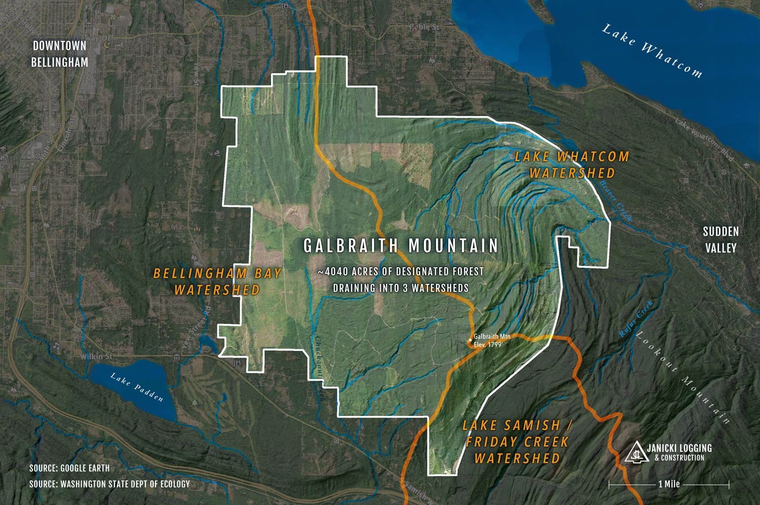
Galbraith Mountain is the commonly known name for the 4,040 acres of designated forestlands sandwiched between the southeast side of Bellingham city limits and the northeast end of Lookout Mountain Forest Preserve. This beautiful North Cascades foothill includes 3,920-acres of public access boasting nearly 65 miles of recreational trails featuring panoramic views of the city, Bellingham Bay, San Juan Islands, Lake Whatcom, Mt. Baker, and the Cascade Range extending well into Canada. The area also penetrates three sensitive watersheds: Bellingham Bay, Lake Samish, and Lake Whatcom - the main source of Bellingham's water supply. With so many abundant and important natural resources, it is easy to understand why Galbraith Mountain is such a prominent fixture of Whatcom County's recreational and agricultural identity.

Janicki Logging has been managing about 70% of the forestlands at “Galby” since 2010. Throughout that time, the accuracy of the GIS tools available for measuring and monitoring the mountain has greatly improved. Below are a few quick facts our business currently relies on that will answer many of the questions people ask us about:
Frequently Asked Questions
Where Is Galbraith Mountain?
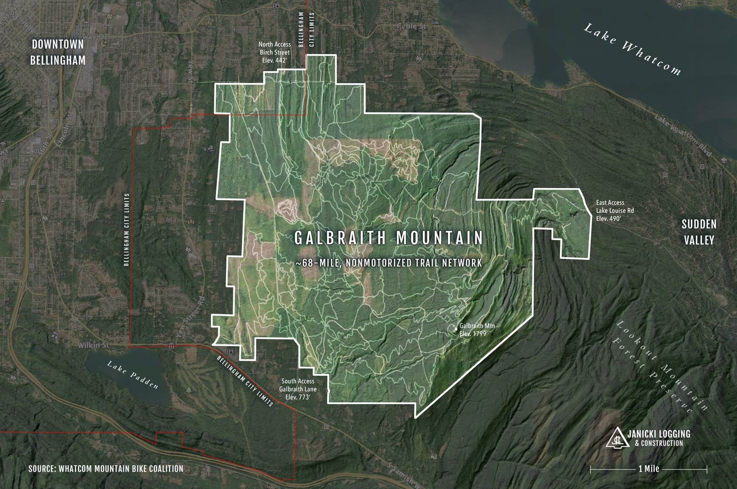
Bellingham, WashingtonWhere Are Galbraith Mountain Trailheads Located?
The southern access at Galbraith Lane and Samish Way parking lot are about 5 miles east of Western Washington University.
The northern access at Birch Street is about 3 miles east of downtown Bellingham. Additional parking may be found nearby at Whatcom Falls Park.
The eastern access at the Lookout Mountain Preserve trailhead parking lot on Lake Louise Rd is about 7 miles east of downtown.What Is The Elevation Of Galbraith Mountain?
1,799 feet / 548 meters (48.7082378, -122.392981)What Is The Elevation Gain At Galbraith Mountain?
South Access To Summit - 1,025 feet (net)
North Access To Summit - 1,356 feet (net)
East Access To Summit - 1,308 feet (net)How Many Acres Is Galbraith Mountain?
4,040 Acres of dedicated forestlands and open space / 3,920 Acres Of Tracts With Public Access (source: Whatcom County Auditor)How Many Miles Of Trails Are At Galbraith Mountain?
The trail system includes approx. 68 miles of user-documented trails, not including fire roads.What Type Of Vehicles Are Allowed At Galbraith Mountain?
Public access is limited to non-motorized vehicles only.How Do I Get A Trail Map Of Galbraith Mountain?
WMBC offers both a printed version and interactive smartphone versions.Who Owns Galbraith Mountain?
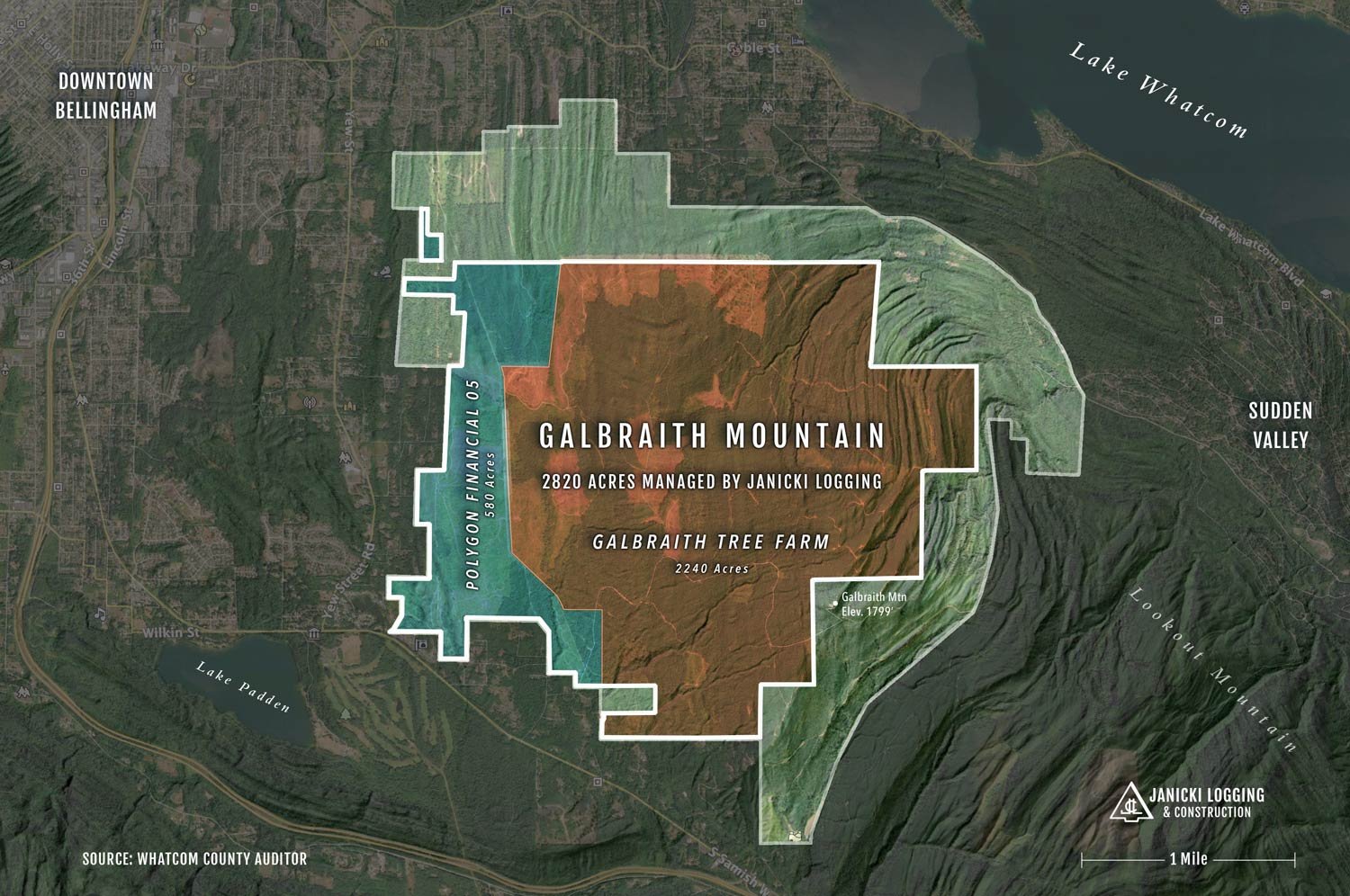
Galbraith Tree Farm, LLC owns the largest portion (2,240 acres), followed by Polygon Financial (580 acres). Janicki Logging manages both properties - 2,820 acres in total. The remaining portions of designated forestlands at Galbraith Mountain are owned by, the state of Washington, Whatcom county, the City of Bellingham, and numerous private landowners.How did Galbraith Mountain get its name?
We know Galbraith Bros Logging built the first road up the mountain, which appears on maps from the 1930s as “Galbraith Logging Road.” In the 1940s, maps had shortened the label to “Galbraith Road,” and locals referred have referred to the area as “Galbraith Mountain” ever since.Is Hunting Allowed at Galbraith Mountain?
No. Any use of firearms or archery equipment is strictly prohibited.
Ever since Janicki Logging first began managing forestlands on Galbraith, we’ve always strived to be sensitive to the concerns of the greater community and have worked to build positive relationships with all of its stakeholders. As a consequence, we’ve made many friends along the way and gained many insights into the mountain’s special place in the history and culture of the local community, and the unique management challenges/opportunities it has and continues to present to all involved.
What follows is just some of that story…
Logging History of Galbraith Mountain
WHATCOM COUNTY PIONEERS & EARLY SETTLERS
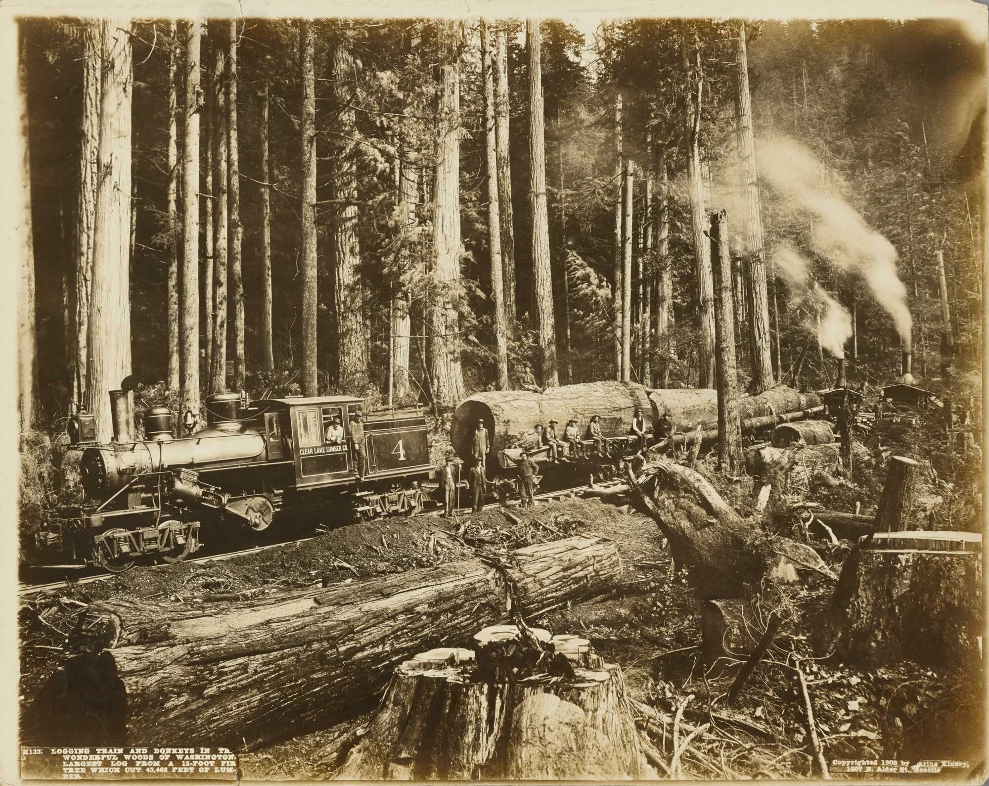
Galbraith's unique place in local logging history goes back to the early 1900s when it became part of the Bloedel-Donovan timber empire. The old-growth stands on the mountain were eventually logged by Galbraith Brothers Logging during the 1930s. The two brothers, Hugh and Andrew, were sons of one of the earliest and best-known settlers in Whatcom County – A.A. Galbraith. (One of A.A.'s other sons, Joseph Galbraith, won the first Mt. Baker Marathon in 1911, …but that's another story)!
Photos shown in this clip of Old Time Logging Galbraith Brothers History, by Galbraith family member John Broten, are believed to have all been taken at present-day Galbraith Mountain.
The oldest record we’ve come across connecting the “Galbraith” name to the mountain is a map from 1934 showing “Galbraith Logging Rd” running up the mountain, which is when the site was first logged - by Galbraith Bros. Logging Company. Later maps shortened the name to “Galbraith Road”; hence locals have referred to the hill as Galbraith Mountain ever since.
Today, most of that original logging road still exists as “Tower Road," leading to the 1798 ft summit.
Since those early days, the land has changed hands and been divided among various owners and land managers, including Janicki Logging. JLC first began operations on Galbraith in 2010 for the mountain’s then single-largest landowner, Polygon Financial, who had recently acquired several parcels totaling 2,820 acres. By this period, it had become clear to us that switching from historical logging practices to much more progressive sustainable forestry would be better for the environment and more profitable over the long term. Fortunately, the new ownership also appreciated this vision, and from day one, we began transitioning operations from a clear-cutting business model to a sustainable forestry model.
Mountain Biking History of Galbraith

When JLC took over managing Polygon's tree farm, we needed to address another type of management issue – Public Access. Local mountain bikers and hikers had been building and enjoying trails on “Galby” since the mid-1970s, which, over the years, had led to tensions with the tree farm’s owners from time to time. Forest landowners very rarely allow public access to their properties due to a host of concerns regarding liability, damage, theft, etc. Galbraith was the exception to this due to a 1990’s agreement between then-owner Trillium Corp and the WIMPS, a local mountain bike group. Even with the deal in place, the relationship between owners and recreationists became contentious until about 2013. This was when new representatives and new logging technologies helped bring about a much more collaborative “win-win” rapport between the mountain’s stakeholders.
Today, the WIMPS have transformed into the Whatcom Mountain Bike Coalition (WMBC) and Galbraith Mountain has become a world-class mountain biking destination featuring approximately 68 miles of non-motorized trails winding through 3,000 plus acres of timberlands. Galby's terrain and route layout are perfect for creating a vast trail system that provides plenty of options for riders of all skill levels. Even with hundreds of riders, hikers, trail runners, and even equestrians on the mountain at the same time, the trails seldom feel too busy, thanks to the excellent network design by the Whatcom Mountain Bike Coalition. And the non-profit WMBC not only designs the ever-evolving trail system but also builds and maintains it. To learn more about how help support their work visit wmbcmtb.org.
Whatcom Mountain Bike Coalition has been collaborating with Janicki Logging regarding public access to Galbraith since 2010 and was instrumental in helping put together the extraordinary conservation/recreation easements that now permanently protect the mountain from development and preserve public access to it. (See below for more about the easement deal).
Here’s WMBC Director Eric Brown, on the easement deal that won Recreation Northwest’s 2019 Great Outdoor Award for Community Collaboration;
2240 Acres Of Privately Owned Forestland With Public Access To Galbraith Mountain

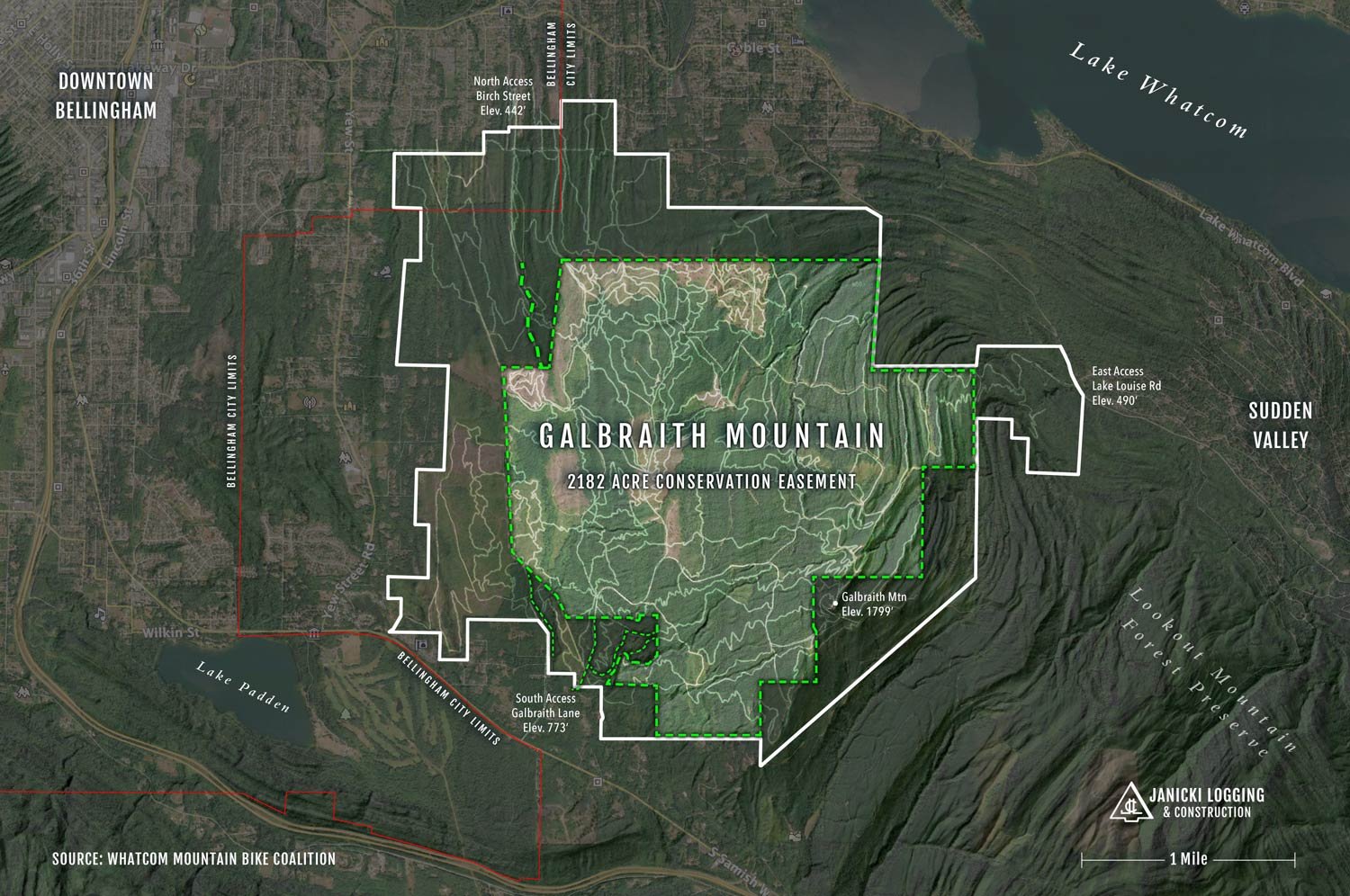
The forestlands on Galbraith Mountain have had several different owners since it was first held by one of Julius Bloedel’s lumber companies nearly a century ago. Today, Galbraith Tree Farm, LLC (GTF) owns most of the working forestland on the mountain when it purchased 2240 acres in 2017.
The first thing that makes managing Galbraith Tree Farm incredibly unique is the conservation easement agreement they entered into with the City of Bellingham and Whatcom Land Trust. This unprecedented public-private agreement permanently protects 2,182 acres on the mountain from future development in perpetuity, including 1,023 -acres within the Lake Whatcom watershed. It preserves public recreational access to the 65 miles of hiking and bike trails on Galbraith Mountain. The agreement includes both a recreational use easement and a conservation easement. Whatcom Land Trust contributed $250,000 to the purchase, and the City of Bellingham Greenway Funds contributed $2.75 million, bringing the total deal to $3 million. As part of the agreement, the world-class trail network on Galbraith will continue to be managed and maintained by Whatcom Mountain Bike Coalition.
Galbraith Tree Farm Owner, Rob Janicki, On The Galbraith Tree Farm Easements.
“The timber industry’s corporate mantra is quarterly yield, but that doesn’t create much value as a long-term view of the trees. The usual practice of clearcutting has a variety of negative impacts on the health of a forest. Aside from wreaking havoc on the local ecosystem, its long-term effects create problems for the logging industry. A monoculture of trees that all share the same level of maturity is much more susceptible to disease and wildfires.“
- Rob Janicki, Owner, Galbraith tree farm, LLC
Another thing that makes Galbraith distinct from most other forestlands JLC manages is that it's a trial ground for testing new and different forestry approaches while systematically shifting it from a monoculture, clear-cut harvest rotation to a polyculture, selective harvest cycle. In other words, once established, rather than the entire mountain repeatedly going back and forth between growing for 35 years and then clear-cut, we'll be selectively harvesting multiple small sections of the tree farm at an annual rate of ~50 acres per year. Our ultimate goal is to convert the entire tree farm into a perpetually biodiverse woodland ranging from meadows to 50–60-year-old stands. This approach creates more sustainable revenue for the tree farm and maximizes the growth yield and quality. And, based on growing evidence that younger forests capture carbon much more quickly than older forests, GTF will also absorb more carbon annually than old-growth stands, let alone traditional clear-cutting practices.
We’ve also been learning how to adapt to the unexpected. For example, high-resolution analysis of the tree farm in 2019 found multiple sections diseased with laminated root rot or poorly performing due to having been replanted decades ago with either low-quality seed stock or inappropriate species for the ground conditions.
After careful consideration, these sections are now being harvested as “mini clear-cuts” as quickly as possible to prevent the disease from spreading further. Disease-resistant species better suited to these respective locations, such as cedar and hemlock, are now being replanted in these spaces. During the years it will take for these tree seedlings to size, these replanted sections will become home to many species of meadow-dwelling flora and fauna that will enhance the mountain’s overall biodiversity.
David Janicki discusses JLC’s approach to managing Laminated Root Rot at Galbraith Tree Farm.
Other issues we are exploring at GTF are adapting to the environmental stresses from the warmer and drier summers, the increasing frequency of extreme heat events we’ve seen in recent decades, and the resulting increases in wildfire risks to the woodlands we manage throughout northwest Washington.
More Galbraith Mountain Related Content
Featured

